Nanki-Kumano Geopark and Yoshino-Kumano National Park - More Information -
The Nanki-Kumano Geopark and Yoshino-Kumano National Park are unique areas with magnificent natural scenery. The sea and valleys are dotted with spots with spectacular views created by nature. You should not miss the historical shrines, temples, castle ruins, hot springs, and festivals. You can make your trip even more interesting by learning about the history, culture, and creatures of the region at the Geopark Center, museums, and aquariums. Trekking is also a great way to get in touch with the sacred energy of the area.
Natural art dotted along the coastline and in waterfalls and canyons
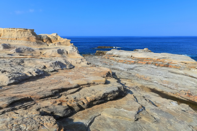
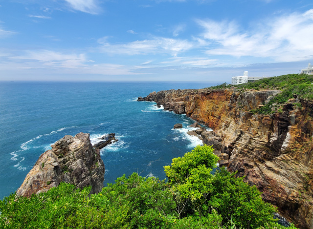
Due to the long history of coastal erosion, Wakayama's coastline is dotted with powerful "natural sculptures." The coastal areas of Wakayama Prefecture are like natural art galleries, with towering cliffs, sea caves, and jagged monoliths. The "Senjojiki," "Hashigui-iwa Rock," and "Sandanbeki/Caves of Sandanbeki" are must-visit spots with spectacular views.
The beauty of waterfalls, ravines, and rivers, such as the World Heritage-listed Nachi Falls and Dorokyo Gorge, are also noteworthy! Another popular way to spend time is to enjoy an active experience by trying river rafting or rafting down part of the Kumano Kodo.
- Senjojiki
- Over the years, the waves have eroded it, creating the current landscape that juts out into the blue sea. As the name suggests, the area is as wide as 1,000 tatami mats, a place where one can feel the power and mystery of nature. Descending the stair-like rock pavement, one can reach the edge of the waves. The view is beautiful as it turns red in the evening sun, and is different from what you can see during the daytime.
- View more
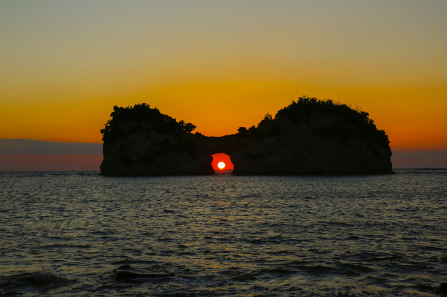
- Engetsuto Island
- An island with a hole in the center that is a familiar symbol of Shirahama. Its official name is "Takashima," but it is called "Engetsuto Island" because of its shape. The silhouette of the setting sun and "Engetsuto Island" is particularly beautiful, and it was selected as one of the "100 best sunsets in Japan". For a few days in spring and fall, there are moments when the sun sets over the hole, creating an even more mysterious scene.
- View more
- Sandanbeki Cave/Sandanbeki Cavern
- The cliffs, which were carved by the power of nature to a height of about 50 meters, run for about 2 km from north to south. The sight of the waves lapping against the rock surface is powerful! After viewing the area from the observatory, follow the boardwalk to the end of the cliffs. The cliffs are rough and rocky, so be sure to wear comfortable shoes such as sneakers.
- View more
- Hashigui-iwa Rock
- About 40 rock pillars of various sizes, created by erosion by the sea, are lined up in a straight row extending for about 850 meters. Some say that the rock pillars, which resemble bridge pilings, are the remains of bridge pilings that Kobo Daishi (Kukai) used to build a bridge to Oshima Island. The artistic landscape is designated as a national natural monument.
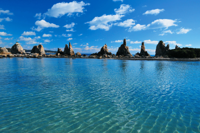
- View more
- Cape Shionomisaki
- Jutting out into the Pacific Ocean, the southernmost cape in Honshu is one of the few spots in the prefecture where you can view the sunrise and sunset. The 360-degree panoramic view from the observatory of the adjacent "Shionomisaki Kanko Tower" is a must-see. Upon entering the tower, visitors will receive a certificate for visiting the southernmost point of Honshu as a souvenir of their trip. At the tip of the cape is the Cape Shionomisaki Lighthouse, where a spiral staircase leads to a view of the Pacific Ocean.
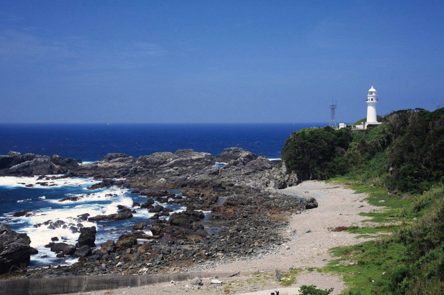
- View more
- Ichimai-iwa Monolith
- At 100 meters high and 500 meters wide, it is one of the largest single rock formations in Japan. Reflecting the calm waters of the Koza-gawa River, visitors can enjoy the seasonal scenery of cherry blossoms in spring and autumn leaves in fall. Legend has it that a long time ago, there lived a demon that loved rocks in Taiji, and a dog protected the monolith from the demon.
- View more
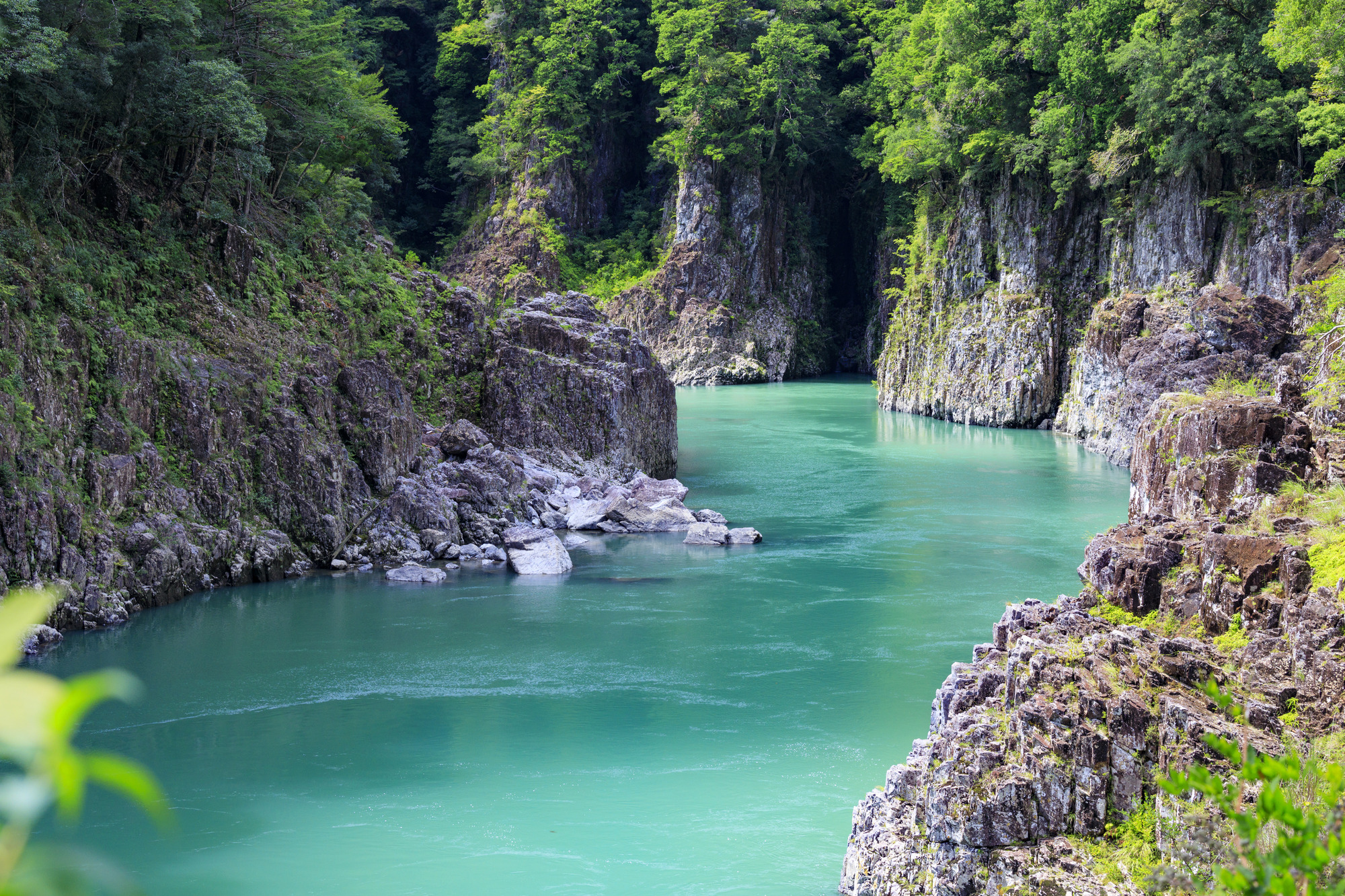
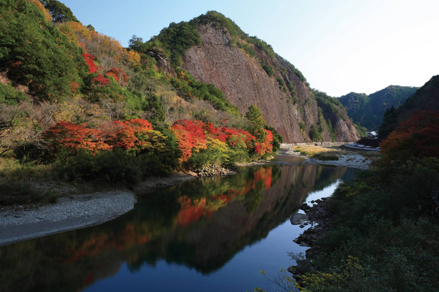
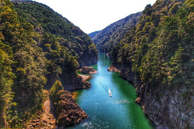
- Doro-kyo Gorge
- The canyon is located on the Kitayama-gawa river, a tributary of the Kumano-gawa river, and is divided into Shimo-Doro, Kami-Doro, and Oku-toro. Eroded over millions of years, the large canyon leaves steep cliffs covered with forests and unusual rock formations. The contrast between the cliffs and the deep, clear turquoise water is beautiful.
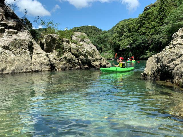
- Koza-gawa River
- The Kozagawa River, which flows between mountains, is one of the representative rivers of Kumano, boasting magnificent and beautiful scenery. The river is so clear that one can see all the way to the bottom, making it perfect for enjoying a variety of river activities. The current is gentle, so even beginners can enjoy the scenery while canoeing. The river has long been known as a river for sweetfish, and is crowded with anglers when the season opens.
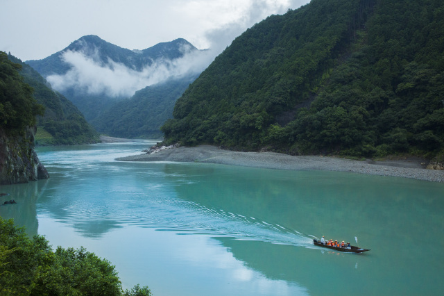
- Kumano-gawa River
- The 183km long Kumano-gawa River straddles the three prefectures of Wakayama, Nara, and Mie. It is registered as a World Heritage site, the "Kumano Kodo River Pilgrimage Route". In the past, aristocrats often traveled between Kumano Hongu Taisha Grand Shrine and Kumano Hayatama Taisha Grand Shrine by boat. Today, river cruising is a popular experience aboard a small wooden boat. Enjoy a short 90-minute cruise while listening to the commentary of a guide with a rich personality.
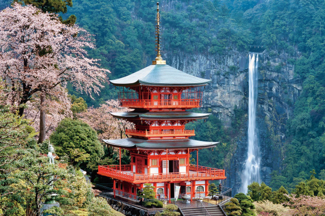
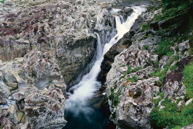
- Nachi Waterfall
- With a drop of approximately 133 meters and a depth of approximately 10 meters, the waterfall is said to fall at a rate of one ton per second, making it one of the three most famous waterfalls in Japan. It is designated as a national scenic beauty and registered as a World Heritage site. Surrounded by forests, the dignified atmosphere and the force of the water are truly breathtaking. If you go through the approach to the temple, you can get close enough to see the spray of the water.
- View more
- Takinohai
- Holes of various sizes, called potholes, can be seen throughout the "Takinohai." They were formed by stones rotated by water currents eroding rock piles. In summer, ayu (sweetfish) congregate in the waterfall basin in the center, making it a famous fishing spot. Tonton fishing, which takes advantage of the topography and does not use bait or decoys, has become an early summer tradition.
- View more
History, culture and its origins
If you want to enjoy the rich nature of the field more, stop by the Geopark Center or the museum and aquarium. You can learn more about the origins and characteristics of the Geopark, as well as the area's history, culture, and creatures.
Be sure to check out the majestic Shinto rituals, fire festivals, and other events, as well as Kumano's unique cuisine and specialties.
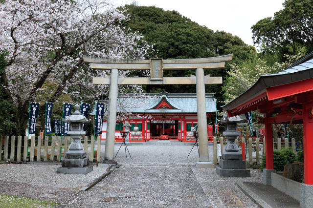
- Asuka-jinja Shrine
- This ancient shrine sits at the foot of Mount Horai near the mouth of the Kumano River. It is registered as a World Heritage site. According to shrine legend, it was founded in 423 B.C.
- View more
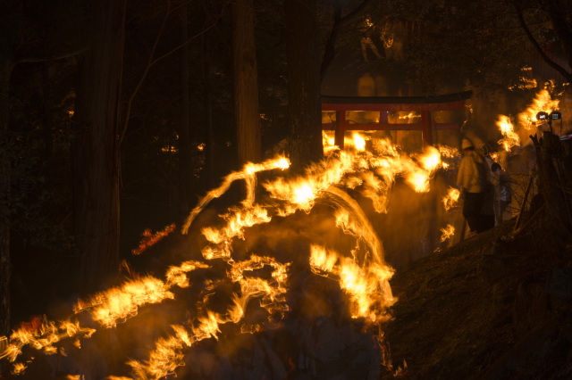
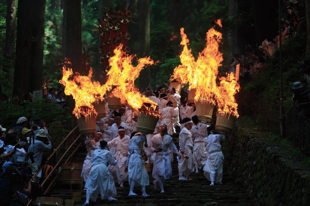
- Oto matsuri Festival
- This is a heroic fire festival held every year on the night of February 6 at Kamikura-jinja Shrine. Two thousand men called "noboriko", dressed in white, gather on Mt. Kamikura. At 7:00 p.m., they run down the steep 538 stone steps from the top of the mountain with torches carrying the sacred fire.
- View more
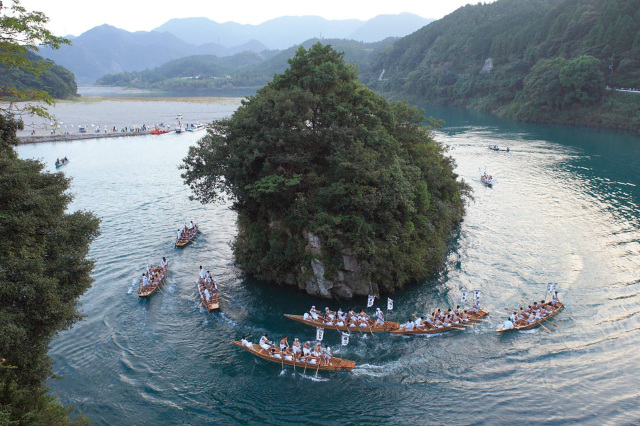
- Mifune-matsuri Festival
- At Kumano Hayatama Taisha Grand Shrine, one of the three major shrines in Kumano, the annual Mifune-matsuri Festival is held on October 16. This festival is a Shinto ritual in which the deity of the shrine is supposed to cross over to Mifune-jima via the Kumano-gawa River; nine rowing boats make three circumnavigations around the island, competing to see how fast they can go. The sight of the boats going forward while almost colliding with each other and the cheering of the spectators is very powerful.
- View more
- Nachi-no-Ogi matsuri (Nachi Fire Festival)
- One of the three major fire festivals in Japan. It is held every year on July 14 at Kumano Nachi Taisha Grand Shrine. Twelve portable shrines with fans attached come out from the main shrine to "Nachi Waterfall" to pray for a good harvest and family safety. Men in traditional costumes lead the portable shrines with large torches weighing 50 to 60 kg, and purify the path with their flames. The sight of the torchbearers walking up and down the approach to the shrine with their vigorous shouts is a powerful sight. The festival is also called "Nachi-no Hi-matsuri" (Nachi Fire Festival) because of the blazing torches.
- View more
- Sukuma-dani Kannon Temple
- This temple is located on a small mountain founded by En no Gyoja, the founder of Shugendo (mountain asceticism), and was rebuilt in 1426 by the Oguri court judge. On his way to the temple, he prayed to the Kannon (Goddess of Mercy) for his horse, which was also unable to move due to illness, and the horse immediately recovered from its illness. The horse's illness was quickly cured, and the Oguri judge gradually regained his health. This legend is said to be the origin of the name.
Even now, many visitors come to the temple as a power spot, enjoying the seasonal scenery of cherry blossoms, hydrangeas, and autumn leaves. 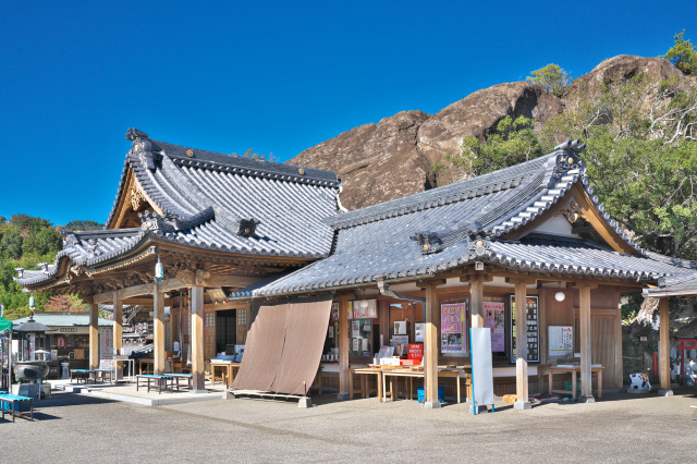
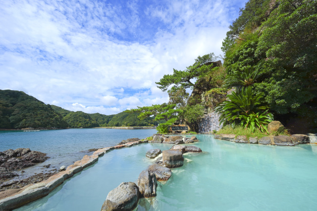
- Katsuura Onsen
- Close to the World Heritage Kumano Kodo, the area is dotted with a rich variety of hot spring facilities, including open-air baths where you can enjoy a sense of oneness with the ocean, mysterious cave baths, and more. At night, the sound of the waves and the star-filled sky will surely soothe your body and soul. We also recommend using a yumeguri ticket to enjoy a one-day trip to the hot spring baths.
- View more
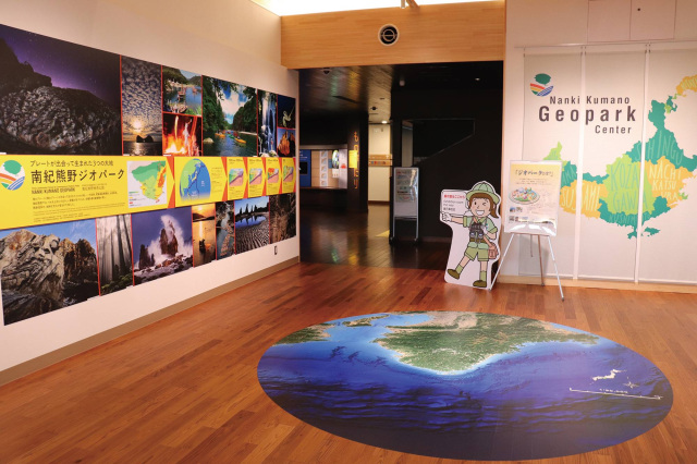
- Nanki-Kumano Geopark Center
- This facility serves as a base for disseminating information and conducting research on the Nanki-Kumano Geopark. With experience devices that recreate the birth of the earth and projection mapping of volcanic eruptions, visitors can experience the dynamism of the Geopark while having fun. Guides are stationed at the center. In addition to explaining about the geo-sites, they also provide information on local sightseeing.
- Minakata Kumagusu Museum
- This exhibition introduces the life and great achievements of Minakata Kumagusu, a world-renowned botanist born in Wakayama. Minakata is known not only for his research on fungi, but also for his efforts in nature conservation and for being a pioneer in ecology.
There is an observation deck on the roof of the memorial hall with a great view, so don't miss the 360-degree panoramic view! 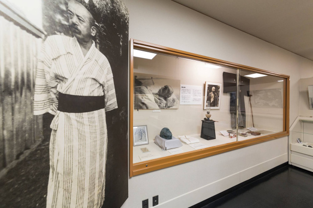
- View more
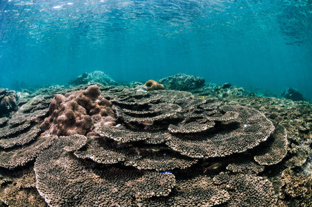
- Kushimoto Marine Park
- Visitors can see colorful tropical fish and the largest colony of table corals in Honshu all year round. At the Underwater Observation Tower, which descends to a depth of 6.3 meters, observation windows line the entire surface. To enjoy a walk under the sea, take a ride on the underwater sightseeing boat "Stella Maris". This type of boat is rare in Japan in that you can observe the sights under the water from both sides, so you can enjoy the feeling of being on a submarine while listening to the explanations of the guide staff. There are also a variety of hands-on programs such as feeding the turtles at the Sea Turtle Park, observing the rocky shore, and diving.
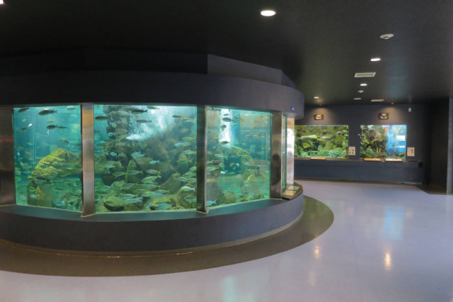
- Kyoto University Shirahama Aquarium
- The aquarium, which exhibits fish living in the Shirahama area, is operated by Kyoto University. The aquarium exhibits and breeds about 500 species, half of which are invertebrates such as corals, sea cucumbers, and shrimps, which often play a minor role in other aquariums. Here, you can observe their shapes and movements up close and personal.
- View more
Trekking is the best way to enjoy the beauty of the mountain scenery
In addition to the ocean and rivers, the scenic beauty of Nanki-Kumano, nestled in the tranquil mountains, is another of its attractions. Trekking here is like a time travel to a mysterious world! Since ancient times, people have made pilgrimages to this place, believing that a god resides here, to experience its sacred energy and heal their hearts.
There are a variety of routes, ranging from easy 3-hour courses that visit typical spots to longer, more substantial courses that include overnight stays. Please choose the course of your choice according to your own physical strength and time.
- Kumano Kodo: Ohechi Route
- It is a 120-km section along the coast from Tanabe City to Nachi-katsuura Town. Many people walked the Nakahechi route when making pilgrimages to Kumano, while the Ohechi route was a path taken by ordinary people and literati who had more time to spare, enjoying the scenery of the Kumano-nada Sea. Nagai-zaka slope is one of the roads along the highway that retains its old-fashioned appearance with its wonderful scenery. Both the ascent and descent are steep, but on the flat road along the way, you can see the vast Pacific Ocean through the trees.
This route, which offers both mountain and ocean views, runs parallel to the JR Kisei Main Line (Kinokuni Line), so you may join the tour from any of the stations depending on your fitness level. 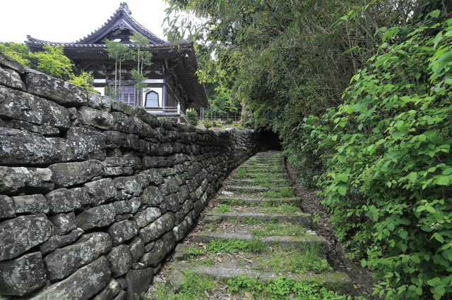
- Daimon-zaka Slope
- The route from "Daimon-zaka Slope" to "Kumano Nachi Taisha Grand Shrine" and "Nachi Waterfall" has the atmosphere of a Kumano ancient road. Passing through a stone torii gate and a vermilion-lacquered bridge, two 800-year-old giant cedars, called "married couple cedar trees," come into view. The atmosphere of the approach changes dramatically after this point. A stone-paved staircase, surrounded by cedar groves, leads up to the sacred mountain of Mt. Nachi.
The route is about 2.7 km long and easy to walk, so it is recommended for beginners. The special experience program, which allows visitors to walk around in ancient "Heian" apparel worn by aristocrats, is popular as a way to experience stepping back in time. 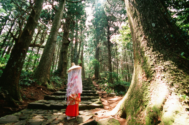
- Ogumotori-goe
- This tour is a walk from Kumano Nachi Taisha Grand Shrine to koguchi, which is connected to the Kogumotori-goe route. As its name suggests, this atmospheric path, which seems to go through the clouds, is said to be the most difficult part of the Kumano Kodo. After repeatedly climbing up and down from the Funami-toge pass, you will reach the Dokiri-zaka slope, where, as the name suggests, you will feel so tired it seems as if your torso is being ripped apart. After passing this point, you will arrive at Waroda-ishi, a legendary rock where the gods of the Kumano Sanzan used to gather and chat, and Koguchi is just around the corner.
If you wish to continue on to Kumano Hongu Taisha Grand Shrine via the Kogumotor-igoe route, you will need to stay overnight at Koguchi, so please make reservations as soon as possible. 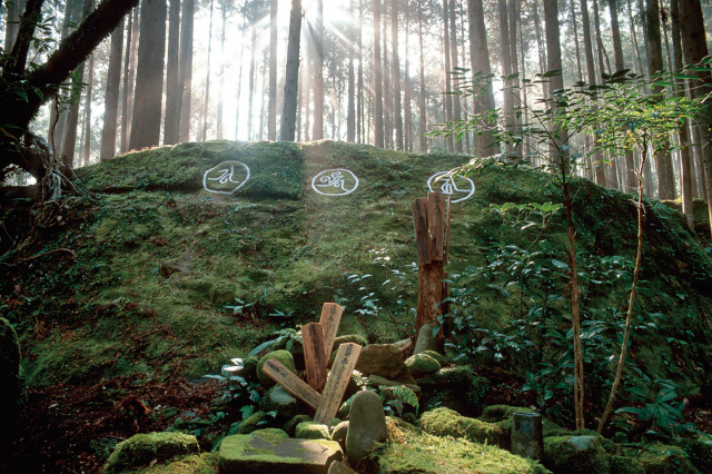
- Kogumotori-goe
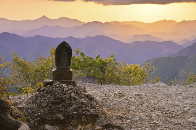
- Continuing from the Oogumotori-goe route, this route leads from Koguchi to Kumano Hongu Taisha Grand Shrine. Although it is a path over the mountains, it is gentle with relatively few ups and downs, so you can enjoy a comfortable trekking experience. Hyakken-gura, which is situated along the way, is the most scenic point along the route! Jizo statue stands at the edge of the cliff, and the magnificent Kii mountain range spreads out before you.
There are also the ruins of a teahouse that was once a resting place for travelers, so take a break while walking along the route.